

A magnetic compass is a tool used for navigation. It works by using the Earth’s magnetic field to determine direction. The magnetic field surrounding Earth has lines of force that are roughly oriented to the north and south magnetic poles.
How to Read a Compass
A compass has four cardinal headings, North (N), East (E), South (S), and West (W). The numbers around the compass are divided by 30° intervals of direction with each interval represented by a number from 0° to 360°.
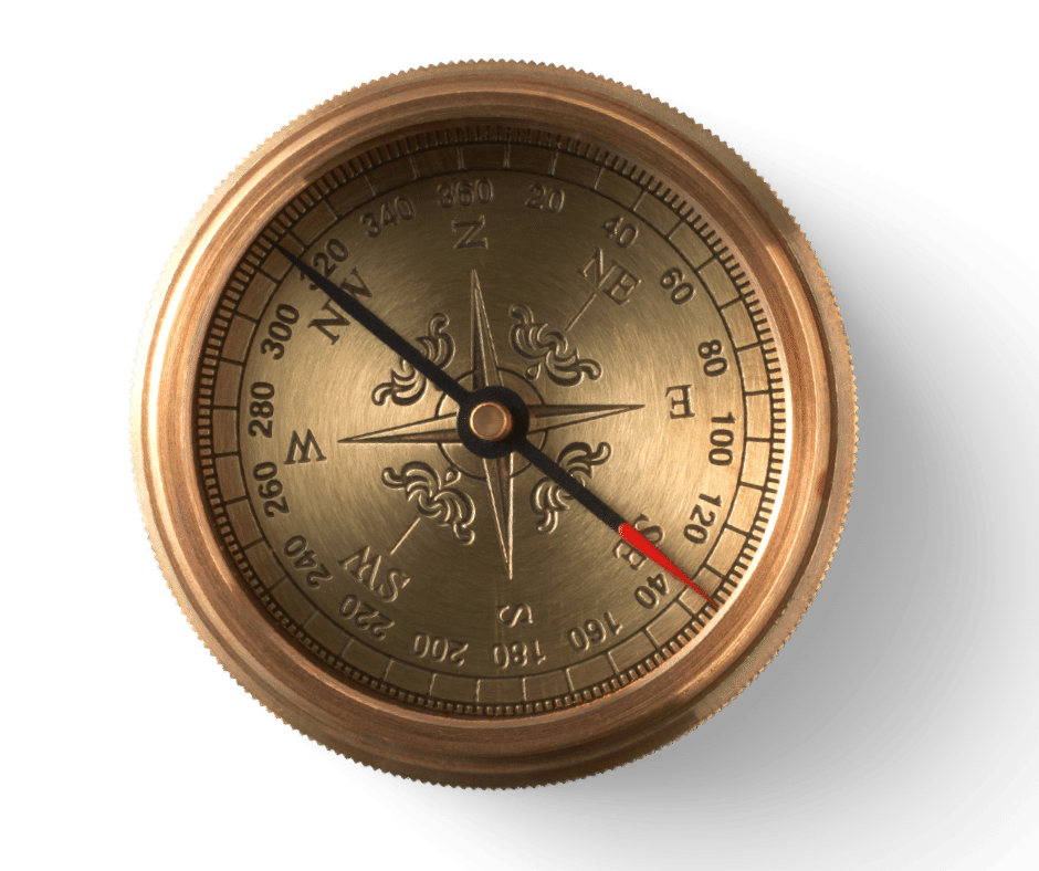
- N represents heading 360° or 0°
- E represents 90°
- S represents 180°
- W represents 270°
While reading headings, the last zero is omitted. For example, 30° is read as 3 and 300° is 30.
There are Many Types of Magnetic Compasses
Baseplate Compass: Common for hiking. A liquid-filled compass set on a transparent base, allowing map viewing. It often includes a magnifying lens, lighting for low visibility, and a ruler, making it suitable for navigation and plotting.
Lensatic or Prismatic Compass: Equipped with a prism or lens for precise alignment with a target. The rotating compass card’s bearing is readable through the prism.
Marine Compass: Includes a fixed needle and a fluid-mounted rotating card, ideal for boats to counteract motion and ease reading.
Aviation Compass: Engineered to withstand the unique conditions of flying, including changes in altitude, vibrations, and the acceleration and deceleration of the aircraft.
Liquid Compass: Features a magnetized needle or card in fluid, minimizing swing and enhancing readability and durability.
Thumb Compass: A compact baseplate compass that attaches to the thumb, keeping one hand free.
Solid State Compasses: Integrated into electronic devices, utilizing magnetic field sensors to determine orientation. Common in phones, tablets, and some watches.
GPS Compass: Utilizes satellite data to provide precise location and direction, independent of magnetic fields.
Astrocompass: Determines true north using astronomical bodies, useful in polar regions where traditional compasses don’t work as well. It requires the current time and geographical coordinates to function.
How to Use a Basic Magnetic Compass to Navigate
To navigate accurately, adjust your compass bearing by adding or subtracting the declination value, which can be found on the map legend. Declination is the difference between magnetic north and true north and can vary by location and change over time.
Hold It Flat: To ensure accuracy, hold the compass flat in your hand at chest level.
Align it with a map: The magnetic needle usually has a red end, which points towards magnetic north. Position your compass on the map so that the edge of the compass aligns with your current location and the destination. Rotate the housing so that the compass north aligns with the map’s north.
Set Your Bearing: Point the compass at a landmark. Rotate the bezel until the needle aligns with the direction-of-travel arrow. The bearing from your position to the landmark is now indicated on the compass dial. Keep the needle aligned with the orientation lines as you move to maintain your bearing.
Follow Your Bearing: To walk in a straight line to a distant landmark, align the compass so the needle is in the orienting arrow. Keep the compass in front of you and walk towards the landmark, ensuring the needle remains aligned. The bezel is marked with degrees from 0 to 360. North is 0 or 360 degrees, east is 90 degrees, south is 180 degrees, and west is 270 degrees.
Be aware of the difference between magnetic north (where the compass points) and true north (geographic north). Depending on your location, you may need to adjust your compass to account for this difference. This information is usually found on the map.
Tips for Using a Magnetic Compass
New navigators often overlook declination adjustments or fail to consider local magnetic anomalies and nearby metal objects, which can lead to significant navigation errors. Metal can also create anomolies in iPhone compasses.
Magnetic North and True Geographic North
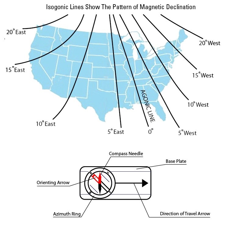
The magnetic field of the Earth is oriented towards the north and south magnetic poles but these are not exactly in line with the geographic poles used to create aeronautical or navigational charts. For example, the needles of a magnetic compass will not point to True North but will point to Magnetic North. Because of this, when plotting courses, the difference between the degrees shown on a compass and the degrees shown on a map must be accounted for by using an isogonic chart or agonic line.
Navigators must allow for the difference between the degrees as shown on a compass and the degrees as shown on a geographic map. The angle betw een a magnetic and the lines of longitude (geographic meridian) is called variation.
If the variation is shown as 9§ E, this means that magnetic north is 9§ east of true north.
Isogonic lines are lines of equal magnetic variations plotted in degrees of east and west on navigational charts. An agonic line is a line connecting points of zero variation—meaning there is no difference between true north and magnetic north.
The isogonic lines below show the pattern of magnetic declination or variation between magnetic north and true north. Isogonic and agonic lines are replotted on navigational charts to correct any changes to shifting poles or local magnetic disturbances that occur on the Earth’s surface over time.
How to Use Compass on iPhone
The iPhone Compass app displays bearings, coordinates, and elevations.
To use, hold iPhone flat to align the crosshairs at the center of the compass. Lock in the direction you are headed by tapping the compass dial. Once locked in, Compass will show a red band whenever you go off course. Tapping the coordinates at the bottom of the screen will open your location in Maps.
Important from Apple: The accuracy of the compass can be affected by magnetic or environmental interference; even the magnets in the iPhone EarPods can cause a deviation. Use the digital compass only for basic navigation assistance. Don’t rely on it to determine precise location, proximity, distance, or direction.
Helpful Resources
Magnetic Field Calculators: https://www.ngdc.noaa.gov/geomag/calculators/magcalc.shtml
View magnetic anomaly maps and data caused by variations in Earth materials and structures for North America: https://mrdata.usgs.gov/magnetic/


